London (The Palestine Telegraph Newspaper) January 26, 2026 - The Met Office has named Storm Chandra expected to deliver heavy rain strong winds and hill snow across parts of the UK particularly impacting south-west England with amber flood warnings. Up to 75mm rainfall forecast over elevated terrain in Devon Cornwall Somerset Dorset alongside 70-80mph gusts Isles Scilly western coasts.
Northern Ireland faces amber wind warnings eastern coasts while yellow rain alerts cover broader regions snow accumulations anticipated northern hills.
Storm Chandra tracks from Atlantic intensifying rapidly central pressure 970hPa nearing British Isles landfall Monday evening through Tuesday. Met Office warnings detail multiple hazards saturated ground conditions exacerbate flash flooding river overflows coastal surges power disruptions travel chaos across affected zones. Emergency services local authorities activate response plans prepositioning resources vulnerable communities ahead peak impacts.
Met office storm chandra naming process warning levels

Met Office named Storm Chandra following Irish Meteorological Service convention low-pressure systems exceeding criteria 960hPa pressure wind speeds 60knots impacts. Three warning levels yellow amber red communicate risk severity yellow be aware amber high impact red extreme danger thresholds established.
Amber rain warnings cover south-west England 25-75mm accumulations 48 hours Dorset Devon Somerset Cornwall highest totals Dartmoor Exmoor moors. Amber wind warnings target eastern Northern Ireland 70mph sustained gusts 90mph exposed coasts building damage tree falls power line failures likely outcomes.
Yellow warnings extend across Wales northern England southern Scotland rain snow combinations hill accumulations 5-20cm elevations above 300m drifting hazards reduced visibility.
South-west england flood risk river levels gauge readings

Environment Agency reports 180 flood alerts 45 warnings south-west region Tamar Otter Taw rivers rising rapidly gauge stations critical Exe Valley Road Dawlish Warren barrier operations. Soil saturation from prior storms Storm Bert December precipitation 400mm monthly totals compounds runoff efficiency reduced infiltration capacities.
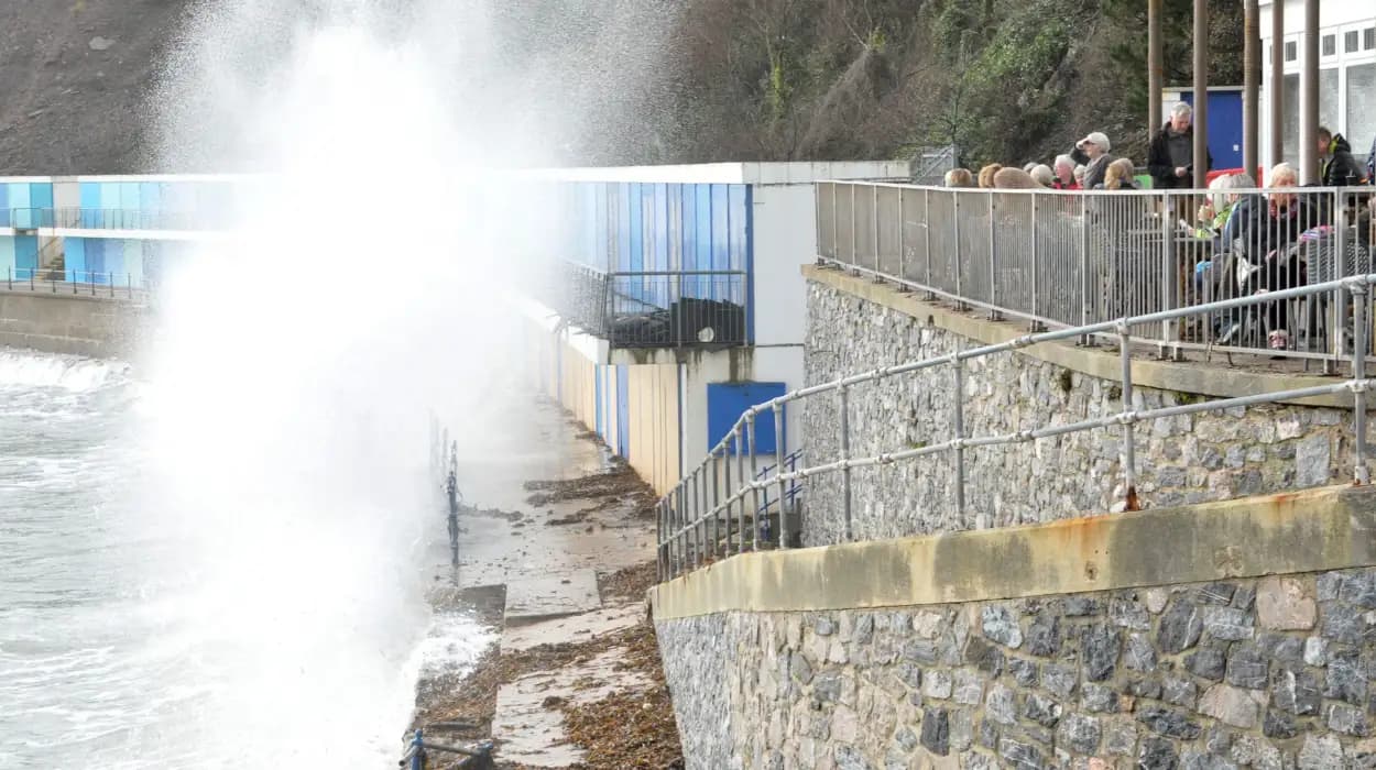
Coastal communities Ilfracombe Lynmouth Combe Martin prepare spring tide overlays 5m surges wave heights 6m overtopping promenades seafront properties. Plymouth Sound Dart Estuary tide locking harbour masters coordinate vessel sheltering dredger standby debris clearance operations.
Northern ireland amber wind warning coastal impacts preparation

Northern Ireland Fire Rescue Service highlighted multi-hazard risks amber wind warning eastern coasts 5am Tuesday duration 16 hours gusts 80mph coastal paths cliffs erosion acceleration rockfalls. Yellow rain warning midnight Monday 120mm totals Mourne Mountains Antrim Glens flash flood corridors urban underpasses tile displacement risks.
Belfast Lough shipping advisories small craft warnings ferry operators P&O Steamers Stena Line schedule reviews standby cancellations. Power NI networks 30,000 customers vulnerability mapping transformer stations reinforcement crews 24/7 deployments.
Wales southwest england yellow rain warning details rainfall
Yellow rain warning Wales southwest England 25-50mm general falls 75mm+ hills hourly intensities 15-20mm thunderstorm cells lightning ground strikes power surges disruptions. Saturated catchments Towy Tywi Wye Usk rivers response times compressed 2-hour peaks downstream propagation flood storage areas activation.
National Resources Wales golden command centres Carmarthen Haverfordwest operational incident management teams multi-agency coordination police fire ambulance health trusts integration.
Scotland northern england hill snow accumulations forecasts
Yellow snow warnings southern Scotland northern Pennines 2-5cm low levels 300m 10-20cm 500m+ brisk winds drifting blizzards white-out conditions hill fog visibility 100m. A9 Aviemore Fort William closures probable winter service vehicles gritters snow blowers 24/7 patrols.
ScotRail service suspensions Highland Mainline West Highland Line bus substitutions layover facilities crew accommodations standby locomotives snow plough fittings.
Infrastructure operators contingency activation protocols established
National Highways smart motorway closures M5 Devon Exe Bridge flood gates A38 A30 Tamar Cross weight restrictions 7.5t limits HGV holding areas services areas prepositioned. Great Western Railway speed restrictions multiple washouts contingency diesel shuttles Newton Abbot Totnes Paignton branches.
South West Water 60 treatment works flood defences emergency diesel generators 72hr fuel stocks chlorine dosing redundancies pressure zone isolations customer notifications.
Local resilience forums activation coordination mechanisms operational
Devon Resilience Forum Category 1 responders convened silver command Exeter operational 72hr rotations welfare hubs 25 centres 1,000 beds elderly vulnerable transport collections. Cornwall Council 180 road closures contingency A394 A388 coastal routes diversionary signage satellite villages isolation risks.
Somerset Levels pumping stations 24/7 Northmoor Popham Burrow Wall 200m3/hr capacities diesel redundancies floating pumps shallow inundations.
Power network operators outage predictions preparations responses
Western Power Distribution SSEN 50,000 properties risk assessment overhead line patrols drone inspections 11kV feeders sectionalising automated fault location isolation restoration prioritisation hospitals emergency services precedence.
National Grid ESO demand disconnection 500MW winter reserve margin 12 percent storm peak 52GW forecasts frequency response services activation.
Royal national lifeboat institution beach status advisories
RNLI 40 stations yellow beach status red flags water entry prohibitions cliff gap patrols drone surveillance missing person protocols. Torbay Falmouth Sennen Cove 12hr crews pager activations inshore lifeboats trailer towing arrangements flood rescue capabilities.
Inshore Fisheries Conservation Officers 12m+ vessel sheltering Falmouth Plymouth Fowey safe havens VHF Channel 16 continuous watch SAR coordination.
Agricultural impacts livestock welfare directives enforcement
National Farmers Union fodder advisories silage protection slurry bunds Environment Agency inspections mandatory livestock evacuation low-lying pastures 48hr notices. Sheep flocks coastal graziers relocation higher ground movements trailer transport coordination veterinary standby antibiotics tetanus prophylaxis.
Rural Payments Agency Basic Payment Scheme force majeure claims automated eligibility criteria storm damage notifications 14-day submissions.
Aviation disruptions airport runway operations limitations
Bristol Airport Category II ILS operations RVR 300m minima crosswind limits 38kts Boeing 737 Airbus A320 diversions Stansted Gatwick contingency fuel uplifts holding stacks. Exeter Airport peripheral flooding runway extensions drainage enhancements standing water displacement swept paths.
Newquay Cornwall Airport gravel runway reinforcement crosswind operations 25kts Ryanair EasyJet cancellations probable accommodation crew hotels standby. South Western Ambulance Service P1 calls 7min median targets 20 percent volume increase projections winter pressures overlay major incident mutual aid Dorset Sussex imports. Derriford Torbay Plymouth Royal Devon generators 96hr endurance fuel escorts secured helipad flood protections.
NHS 111 telephone tree warnings automated vulnerable registers daily outbound calls welfare checks neighbour checks protocols.
Education department school transport closure criteria triggers
Department Education headteacher authorisations amber triggers overnight 50mm precipitation 50mph winds travel disruptions multi-pathway assessments. Cornwall 120 schools coastal rural priorities distance learning platforms Oak National Academy resources prepositioned.
Devon County Council 40 percent bus cancellations primary salting A38 A30 A361 North Devon Link continuous gritting regimes.
Telecommunications network resilience mobile mast protections
Openreach copper NGA cabinets flood skirts 1m elevations diesel generators solar hybrid power 48hr endurance satellite backhaul LOS microwave links diversity paths. EE Vodafone Three 5G emergency services priority resilient core network tunnels hardened facilities regional switches.
Ofcom emergency calling 999 resilience testing annual compliance reports network sharing agreements spectrum pooling crisis declaration triggers.
Environment agency flood defence asset performance monitoring
12 permanent tidal barriers Bridgwater Barnstaple manual actuation 4m triggers demountable Teignmouth Dawlish 2km steel panels crane standby. Temporary defences 500,000 sandbags self-service stations CCTV 24hr access flood wardens 2,000 volunteers radio nets village command posts.
Floodline warnings 5 million sign-ups text phone email check service GOV.UK register options multiple contacts household coverage.
Met office nowcasting radar updates hourly bulletins issuance
Nimrod Doppler radar hourly nowcasts QPE accumulations real-time calibration rain gauge networks validation. Satellite imagery Meteosat visible infrared channels vorticity tracking jet stream ridge analyses model verification ECMWF UKV blends.
Public weather app notifications push alerts warning polygons precise location impacts street-level resolution hazard proximity alerts.